从卫星视图测量土地、道路、公园、国家、湖泊等。 计算距离、区域和周长。
此应用程序提供大多数竞争对手没有的功能:
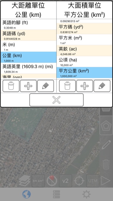
- 添加自定义的距离和面积单位。
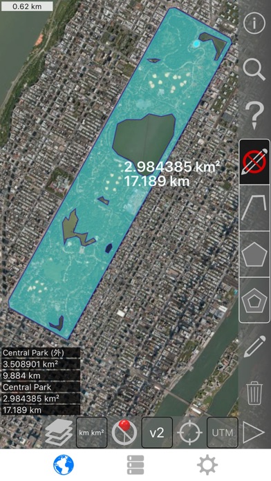
- 绘制室内多边形。 例如,土地面积与水体中删除。
- 将点添加到路径的中间 (大部分只允许您将添加到路径末尾) 自来水将添加到路径的结尾。 长按要添加到中间的一条道路。
- 交换路径或多边形中的两个点。
- 从 GPS 接收机添加您当前的位置。
特点:
- 3 的地图图层选项
- 导出和导入.kml 文件通过 Dropbox、 iCloud、 电子邮件等
- 引脚可拖动并手动编辑
- 名称,注意到,并颜色每个路径和多边形的字段
- 通过电子邮件或文本消息路径和多边形数据
- 4 详细模式。 仅查看要查看的信息
- 按邮政编码、 城市、 地址等搜索
- 在地图上的点附近获取地址
4 种绘图模式:
- 路径
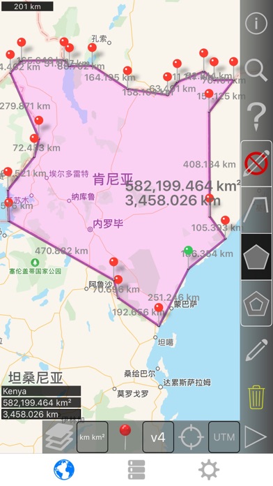
- 多边形
- 与空心空格内多边形
- 没有编辑模式 (以防止意外编辑)
显示路径的值:
- 总距离
- 每个航点的增量距离
对于多边形显示的值:
- 地区
- 外围
- 为每个边的的距离
将点添加到路径或多边形中的四种方法 1:
- 点击地图
- 使用您当前的位置
- 手动输入坐标
- 导入.kml 文件
默认距离单位包括:
- 米
- 英尺
- 码
- 公里
- 英里
- 航海里程
默认地区单位包括:
- 平方公尺
- 平方尺
- 平方码
- 平方千米
- 平方英哩
- 平方海里
- 平方英亩
- 平方公顷
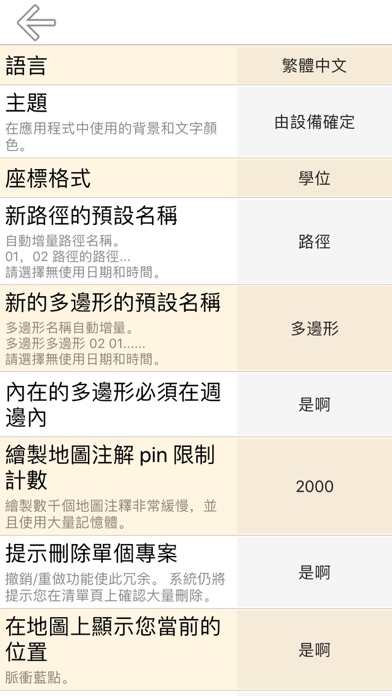
坐标格式:
- 度
- 度,分钟
- 度,分钟秒
- UTM / UPS (通用横向墨卡托) / (通用极性立体)
- MGRS(军用电网参考系统)
English:
Measure land, roads, parks, countries, lakes, etc from a satellite view. Calculates distances, areas, and perimeters.
Features that this application offers that most competitors do not:
- Add custom distance and area units.
- Draw interior polygons. For example, land area with bodies of water removed.
- Add a point to the middle of a path (Most only allow you to add to the end of the path) Tap to add to the end of a path. Long press to add to the middle of a path.
- Swap two points in a path or polygon.
- Add your current location from GPS receiver.
Features:
- 3 map layer options
- Export and import .kml files via Dropbox, iCloud, email, etc
- Pins are draggable and manually editable
- Name, notes, and color fields for each path and polygon
- Email or text message path and polygon data
- 4 verbosity modes. See only the information that you want to see
- Search by postal code, city, address, etc
- Get addresses near point on map
4 drawing modes:
- Path
- Polygon
- Polygon with hollow spaces inside
- No edit mode (to prevent accidental edits)
Values displayed for paths:
- Total distance
- Incremental distance for each waypoint
Values displayed for polygons:
- Area
- Perimeter
- Distance for each side
Add points to a path or polygon in 1 of 4 ways:
- Tap on the map
- Use current location
- Enter coordinates manually
- Import .kml file
Default distance units include:
- Meter
- Foot
- Yard
- Kilometer
- Mile
- Nautical mile
Default area units include:
- Square meter
- Square foot
- Square yard
- Square kilometer
- Square mile
- Square nautical mile
- Square acre
- Square hectare
Coordinate formats:
- Degrees
- Degrees, minutes
- Degrees, minutes, seconds
- UTM / UPS (Universal Transverse Mercator) / (Universal Polar Stereographic)
- MGRS (Military Grid Reference System)
距离和面积测量 V2.5更新日志:
- 更好地支持黑暗主题和新设备。
- 小界面和布局更改。
- 最近添加的 UTM 和 MGRS 坐标格式的错误修复。
English:
- Better support for dark theme and new devices.
- Minor interface and layout changes.
- Bug fixes for the recently added UTM and MGRS coordinate formats.
Please send crash reports if crashes occur.
Please contact the developer via email if you have questions or notice any errors or issues.

 抖音极速版 - 集音符兑好礼摄影与录像立即下载
 昆明地铁-昆明地铁公交e路通导航立即下载
 今日头条极速版资讯立即下载
 相机360 - 潮流P图新玩法摄影与录像立即下载
 儿歌多多-听故事看动画片玩游戏音乐立即下载
 腾讯会议-多人实时视频会议软件效率立即下载
 Adobe Lightroom 专业相机修图・照片滤镜编辑图形和设计立即下载
 中公教育资讯立即下载
 下载
下载
 下载
下载

 下载
下载
 下载
下载
 下载
下载
 下载
下载
 全球购骑士特权立即下载
 每日环球展览 iMuseum · iDaily Museum立即下载
 顺风车司机版-顺风车司机端立即下载
 租租车-车多便宜免押金立即下载
 花小猪司机端-车主招募平台首选立即下载
 去哪儿旅行-预订特价机票酒店火车票平台立即下载
 拼车-顺风车立即下载
 智行火车票-高铁抢票、机票酒店汽车票预订平台立即下载
 亿通行-公共交通票务平台立即下载
 蚂蚁短租-去旅游,住民宿,选蚂蚁短租立即下载
 一月学会法语
![法语会话专家[PRO]](http://tu.diyiapp.com/appstore/20222821/202203282110bweiywcnib2612.jpg) 法语会话专家[PRO]
法语会话专家[PRO] 南非语 中文 翻译 和 词典
 法语日常用语 - 轻松学习法语口语基本会话短语句型
 克里奥尔语 翻译 和 词典 海地
 学习法语 - AccelaStudy®
 GPS追踪器 - 返回地点:失落的位置搜索
 哥里旅游攻略、格鲁吉亚
 格拉茨旅游攻略、奥地利
 特价机票, 价格比较和航空公司 机票门票预订助手 携程 机票